HISTORY OF THE HURRICANE BENCH
(Hurricane, Utah)
A Synopsis By:
Introduction
Soon after the Mormon Saints arrived in the Salt Lake Valley in July of 1847, their Prophet and leader, Brigham Young, began to secure the routes into the Great Basin by establishing settlements on its perimeter. These settlements were established not only for security, but to establish trade with migrants headed for California and Oregon. An additional purpose was to facilitate the gathering of the Saints to the New Jerusalem. Settlements were started in the Carson Valley in Nevada, San Bernardino, California (abandoned in 1857 because of the threat of Johnsons Army), and in 1855 Las Vegas, Nevada. Fort Bridger, Wyoming was purchased in 1853 and Fort Supply on Smiths fork of the Green River was founded in November of 1853. The Salmon River Lamanite Mission was developed in the Northwest. On the East near Moab the Elk Mountain Mission was started, but was later abandoned because of Indian Hostilities. Connection to the Old Spanish Trail in Utah provided a late year route into and out of California and many settlements were established near this route for the same purposes as above.
The earliest settlement into the Southern Utah area, which became the mother settlement for many others, was established at Parowan in 1851 by Parley P. Pratt. Because of Brighams desire to establish self reliance for critical goods such as cotton experimental settlements were established in the warm climate of the Virgin River basin which would potentially grow crops commonly found in the southeastern part of the United States. Developing hostilities between the States helped precipitate this philosophy, but generally because of the cost of transport and perceived unreliability of goods it was believed that production of cotton, sugar, grapes, tobacco, figs, almonds, olive oil and other useful materials would be essential to the well being of the Saints. The following settlements were established: Fort Harmony 1852, Santa Clara 1854, Tonaquint 1856, Washington 1857, Toquerville 1858, Heberville 1858, Harrisburg 1859, Virgin City 1858, Grafton 1859 and Rockville 1860.
The Territorial Legislatures committee on Agriculture, Trade and Manufacturing produced a favorable report that good cotton could be grown in the Virgin River Basin from Grafton to Santa Clara. Brigham Young and other officials of the Church inspected first hand and determined that cotton production could be accomplished. They decided to call a large group to go south to strengthen the settlements already there and to build St. George. The call to 309 families came in October 1861.
Hurricane Bench
For nearly 40 years the communities that lined the banks of the Virgin River and its tributaries grew. The original settling families increased in number while the river during spring and summer floods tore at its banks, diminishing the amount of irrigable land. The families became concerned that there would not be enough land to sustain their families and certainly not enough to divide land so sons could remain at home and have adequate land to raise families on. And indeed some families moved as a result. For example moves were made to Hinckley, Deseret and Delta in Millard County, to Arizona and other locations.
During this time the arid but fertile land on the LaVerkin & Hurricane benches were looked on with desire for expansion, only if there could be water to irrigate with. There was already considerable use of the benches for natural pasture. Because of interest several surveys were made after the settlement of St. George to evaluate the possibility of building a canal.
Sometime during the 1860s Erastus Snow and John M. Macfarlane, pioneer surveyor conducted a survey to determine the feasibility of bringing water out of the Virgin River to the bench. Macfarlane decided at the time it was not feasible and no project was started. Shortly after this survey Erastus Snow and David H. Cannon with mules and buggy traveled via Virgin to explore the Canaan country, where a cooperative cattle herd was later established. This road led from Virgin southwest to a large, higher, relative flat country known as Goolds and later as part of the Arizona Strip. Snow & Cannon asked Nephi Johnson if it was possible to get over the hill (Hurricane Fault) with their buggy, so they would not have to back track to Virgin. Johnson, thought that with ropes and horses the light buggy could be let down over the trail that existed down the steep hillside. They accomplished this task and when at the bottom of the hill a whirlwind developed and tore the top of the buggy off. Erastus Snow exclaimed Well, that was a hurricane! Well call this place Hurricane Hill. And so it was, the hill, the fault, the bench, canal and town was subsequently named HURRICANE.
Later, in 1874 President Young visited the area with his son John W. Young along with the intent of giving him a responsible position in the Cotton Mission. During this time John Young, with the assistance of three young men from Virgin, explored the area south and west of Virgin City. These men were called by John Parker, the Presiding Elder of the Church at Virgin, to assist Young in this exploration. Young had the idea that water could be brought over the hills and put on the Hurricane Bench. At Big Wash, the lowest point over which the water could be taken, the rest being down hill, Young used a leveling instrument to sight up river toward Rockville. He did not like his observation and stated that the water would have to be taken out of the river above Rockville. Its impracticable, Im going home, was his reaction, and true to his word, went home. This ended the second feasibility study of getting water to the Hurricane Bench.
Hurricane Canal
 Interest continued in getting water onto the Hurricane Bench. Meetings between John Steele of Toquerville and James Jepson of Virgin sparked renewed interest. Steele met Jepson with his spirit leveler at a place Jepson had picked out for a dam site between Virgin and Hurricane at the end of a deep box canyon. They concluded the location merited consideration. Jepson was to try and develop interest up river and Steele was to try and incite interest in Toquerville. As a result a committee of 6 was formed to investigate the feasibility of a canal through the canyon. The committee met at the proposed dam site, split up with half exploring downstream and half exploring from the top of the canyon. They met at the hot springs where the canyon begins to open up. After a discussion they decided to make a favorable report for the canal project.
The Hurricane Canal Company records its first meeting to have been held at the Toquerville Hall on July 11, 1893 (As a preface to the Canal Company record 156 names are listed as members of the Hurricane Canal Company. These individuals represented all settlements in the east end of Washington County). The purpose of the meeting was to appoint 3 delegates to meet at Virgin City with delegates from the up river settlements to set up a temporary organization of ascertaining the feasibility of diverting water from the river through a canal to the Hurricane bench for irrigation & culinary purposes. This meeting also approved the notion that the temporary committee would be able to empower a survey and an assessment to provide the means to pay for it. The assessment was 5 cents per share, 3 cents to be paid at or before the commencement of the survey and 2 cents when it was completed. Four days later on Saturday July 15, 1893, the delegates from the various communities met and elected officers (president, secretary & 3 directors) to act as an executive committee of the temporary organization. The meeting also authorized the Executive Committee to levy the assessment mentioned above to meet the costs of the survey. After the survey was finished each member of the Executive Committee was to meet with stockholders in his area to review the results of the survey.
On August 25, 1893 the report by the county surveyor, Isaac Macfarlane was heard. The stockholders learned that the proposed length of the canal would be about 7 miles long and irrigate about 2,000 acres of land. To divert the water from the river into the canal a dam 15 feet high would be necessary. An estimate of the cost was not possible until the surveyor made a final survey and estimates. The report was accepted and a motion for the work to begin was made. A motion was also made to incorporate the Canal Company and a committee was selected by the stockholders to draft the articles of incorporation. With the legal requirements completed the articles of incorporation were recorded, a certificate of incorporation was issued, the elected officials filed the necessary bonds, took the oath of office and representing the company began to conduct its business.
On October 20, 1893 the directors met to organize. They made James Jepson president, Joshua T. Willis vice-president and Levi N. Harmon secretary. The Board authorized the President to have the necessary surveys done and assigned Martin Slack to draft the bylaws. The stockholders also agreed to limit any one man to a maximum of 20 acres because of the concern that all the young men would be able to have homes and farms rather than have a few large land holders owning most of the land. An exception to this rule was men with grown sons could get twenty acres for each of them. Of the 53 men who signed the articles of incorporation, only one received 40 acres. The majority had 20; four had 10 and one fifteen acres.
On Oct.24, 1893 a tax of 8 cents per share was levied to care for the cost of the permanent survey. J. T. Willis was appointed to make arrangements for the survey, keep an expense record & report to the secretary. He was also appointed as superintendent of construction. Willis allowed $2.00/day to those making the survey, wages for an 8 hour day were fixed at $2.00. The stockholders authorized the Board to let contracts for building the canal and to furnish necessary supplies, such as lumber, powder etc. A labor assessment was made of $2.50 per share to be completed by May 1, 1894 and the work on the canal commenced.
As mentioned the canal was built by the contract method. The working survey laid out the route in 4 rod stations (100ft.??), with estimates of cost based on $2.00/day. Fifteen cents per cubic yard was allowed for ordinary earth excavation, 75 cents/cubic yard for loose rock and gravel and $1.25/cubic yard for solid rock. Each station was examined and estimates made of the construction it entailed, they were numbered by pegs, with the price marked on the peg. The upper part of the canal was worked first and the choice of stations given to those who got there first to take the contracts. Payment was only made on work completed, so the industrious were rewarded and the slothful only paid for work accomplished.
The work was not only difficult, as all work was done with pick, shovel, hand held drills, wheelbarrow and pry bar, but access was difficult. There was no road into the canyon and everything needed at the dam site and for considerable distance down the canyon had to be carried from the top down into the canyon, across the river to where the canal began. Food, tools, bedding and in fact all supplies used that first year had to be carried down on the backs of the men who worked there. The workers camped in the open the first year in very primitive living quarters. Their first shelters were wagon covers anchored to rocks and pegged down to the ground. This provided a lean to for beds. Cooking was done over an open fire. The workers worked all day on the canal then gathered driftwood to make the cooking fires and for warmth. This was the hardest winter, as later a road up the north side of the river was built allowing wagon boxes to be used for shelter. This road also greatly assisted in the transportation of supplies into the canyon.
The formation through which the canal was built was of conglomerate and lime stone. Only one place existed where the route went through gypsum. This location gave a lot of trouble when the water was put into the canal. However, in later years cementing fixed the situation. Rock fills were required in many places to provide a base upon which to build the canal. These were of questionable permanence, but had to be used because of the limited resources of the builders. Experience had been gained by some workers who had worked on the LaVerkin Canal* and this was a great benefit to the work.
The Canal Company Directors decided to build the Dam during the winter of 1894-95 and solicited bids for its construction. The specifications were for a structure 75 feet thick, up & down the river, and 5 feet higher than the bottom of the canal. The Canal Co. accepted the bid from the Isom Company for $1,000.00 to build the dam according to the specifications. The river was 40 feet wide at the point of the dam. The sides and bottom of the river are of solid rock with the north side of solid limestone rising perpendicular for a 100 feet. On the south was a rock that rose 9 feet to a shelf above the level of the river. The site was excellent, but inexperience in building a dam under the circumstances existing led to much trouble before a dam was permanently established.
The first dam consisting of large rocks (some many tons) were shot down from the cliffs above as anchors with smaller ones filling in the spaces. It looked indestructible and the work was paid. This dam was destroyed by a flood, lasting about 1 year. The second dam was designed differently with a very large log laid in slots mined out of the rock on the river sides, with smaller logs laid with their butts on the large log pointing up stream. This mass was weighted down with rocks. This dam held for a time, but a large flood lifted the large log and its load out of its slot and washed it down river. The third dam was similar. The large log was retrieved & put back into its slot, with its load of timbers. A second layer was added and then the whole mass was bound together with heavy galvanized wire woven among the timbers. This time the Dam held.
Time dragged on with the canal remaining unfinished. The workmen were unable to devote all their time to the task as they also had to farm to survive. The work they did on the canal had to come from November to March. The women stayed home in these winter months while their husbands and older sons worked away at the canal.
The canal slowly took form as the years passed, but when the work approached the last mile (near the hot springs) in the canyon, and by far the most difficult, the problems encountered became so severe that the work was almost stalemated.
[It was near the hot springs that the only serious accident occurred on the project. The workmen were rolling rocks down from above to make a fill and one struck John Isom in the head and killed him instantly.]
This slow down of the work presented a major problem for the Canal Company. They had filed for title to the land under the Desert Land Act, which required water to be put on the land in 4 years. Even though their filing was not done until 2 years after construction had started, they found it impossible to comply with the 4 year rule and the land reverted back to the Government. The Company then authorized the stockholders to individually file on the land in order to secure title from the State of Utah. By April 1902, 1400 shares had been taken by 75 individuals.
This winter of 1901/1902 was a critical point. During the winter only 7 or 8 men continued to work on the canal. The stockholders had previously considered appealing to the Mormon Church for help, but now found it a necessity. In January of 1902 the Board decided to send a personal envoy to see President Joseph F. Smith to obtain an appropriation to assist the company. On January 20, 1902 James Jepson left for Salt Lake City (by train from Lund, Utah) carrying a history and letter of appeal signed by Bishops of the Wards interested in the project. This appeal was successful and the Church agreed to buy $5,000.00 worth of stock in the Company.
This injection of capital into the venture was just what the project needed. The work moved forward rapidly and water flowed through the canal to the Hurricane Bench for the first time on August 6, 1904 nearly 11 years after the project began.
Even after the water began to flow onto the bench primary water rights had not yet been acquired. The Hurricane Canal Company Board began the process at their meeting on January 12 1895, when they made the decision to file a petition with the Water Commissioners Court of Washington County. When the Court met on March 14, 1895 the Canal Company requested a primary right to 4,000 inches of water from the Virgin. As the petition had been posted according to law, it drew opposition from both the Washington Field Canal Company and the LaVerkin Fruit and Nursery Company. These two groups filed a protest on the basis that the request infringed on their previously acquired rights. At a meeting on June 3, 1895 it was decided to appoint a committee to measure the waters of the Virgin and investigate the claims of the three companies.
The committee completed their investigations and measured the water at its low stage during the summer months. When the water reached its low mark, the amount of primary water right already granted before the Hurricane Canal Company petition was 670 inches in excess of what they found in the river as opposed to the requested 4000 inches. In light of the findings it was hardly logical that a recommendation to grant the petition would be made. However, the committee did state that they could not account for the water that existed in the quicksand bottom of the river and they noted that experience had shown that when large quantities of water was removed those below had not suffered, and a sufficient amount of water had been found to water all lands under cultivation. The Water Commissioners Court accepted the recommendation of the committee that the petition be denied. However, the Court granted the Hurricane Canal Company a first secondary right to 4,000 miners inches of water from the Virgin River.
The decision did not seem fair or just to the Canal Company Stockholders. They had previously held primary water right for the lands that had been washed away at Virgin, Grafton, Rockville, and Springdale, and felt that they were entitled to transfer those rights to Hurricane Bench. They also contended that the water used on the bench would find its way back into the Virgin by seepage because of the difference in elevation. Even though the stockholders believed they would win in a court battle, they didnt want to pursue one, because of the animosity it would provoke and it wouldnt generate more water in the river. They concluded that in the end the water users wouldnt benefit, that only lawyers would, and that there would be a residue of hard feelings. Fortunately, both sides were guided by this logic and although the matter existed for 30 years an amicable settlement was reached. The Washington Canal Company received 30 second feet, LaVerkin Canal Company 6, and the Hurricane Canal Company 9 second feet of primary water right.
Settling the Hurricane Bench
Water came to the bench in 1904, but it wasnt until 1906 that the first family took up residence. Crops were planted and harvested during the intervening years by the stockholders and owners of the land. Some camped in tents during the week returning home on weekends. Others commuted by horseback from the nearby towns. For example it was a 30 minute ride by horse from Virgin City, while wagons took much longer. In 1906 Thomas M. Hinton built a lumber granary for Thomas Isom. This granary was used as a home by the Hintons and they became the first residents of Hurricane.
In 1896 the town site was laid out and prior to any farming activity on the bench and before the stockholders had a chance to decide which were the best areas their farms and town lots were selected by lottery, this to avoid favoritism. The names of the stockholders were placed in one box and the numbers of the lots in another; the name was drawn from the box, and the person drawn had the right to draw out of the other box his lot. The four lots of Block 14 were withheld to serve as a public square.
In her book Portraits of the Hurricane Pioneers, Janice Force DeMille lists 37 families by name which had settled In Hurricane by 1912 or soon thereafter. A review of the move dates of these families indicated that the majority arrived on the Hurricane Bench during the period 1906 to 1909. Most but not all came from the up river communities, e.g., Virgin, Grafton, Rockville & Shonesburg.
Schools
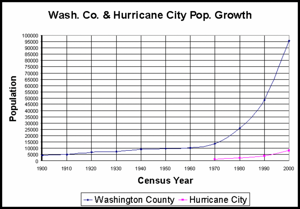
Hurricane grew fast. By 1917 the original 11 families of 1906 had grown to 100 families and a population of 800. The first school was held in Ira E. Bradshaws home in the winter of 1906. The next winter the LDS meeting house had been built and was used for school and church.
In 1912 the LDS Ward had finished the Relief Society building and the school had use of this building. An elementary school building was finished in the spring of 1918, but prior to this buildings completion school was being held in 3 different buildings. High school instruction was started in 1918 but the growth was slow until 1928. By 1935 the pressure for schools was so great that a new high school building was begun and was ready for use in December 1936. (This building was demolished and the ground leveled in the spring of 2004.)
Other buildings & services
Post Office The government was petitioned for a 4th class post office in Hurricane in about 1910. It was located in a small lumber building on J. L. Workmans lot. On November 1, 1918 the post office was moved to the Petty Building. It was changed to a 3rd class post office in 1923. In January 1928 it was moved to the Sandberg Building. It was later moved into a separate building immediately south of the Sandberg Building, and is currently in a new spacious facility near Lins Market on West State Street.
Airport In March 1944 the Mayor & City Council took the opportunity to get an airport for the city. With the aid of the city, the State of Utah and the Civil Aeronutics Administration a paved strip 3400 feet long was finished in 1949. A Hanger was built in 1947, again with the assistance of the City, the State and donations of money and labor. The Airport was changed from a class 1 to a class 2 airport in the summer of 1949.
* LaVerkin Canal: This project was launched as a private enterprise in 1888 by Thomas Judd & Thomas P. Cottam. In June 1889 the LaVerkin Fruit & Nursery Company was organized and incorporated. Thomas Judd served as president. Work commenced on the canal shortly after this date and was mile long with a 40 rod (~1000 ft.) tunnel through the LaVerkin Hill. Problems encountered were much the same as described in building the Hurricane Canal, with gypsum formations giving the most problem after water was flowing. Water began to flow in April 1891. Because of problems the Company sold part of their stock to meet expenses in keeping the water flowing. This brought more people to the LaVerkin bench and with people farming their own land the project began to advance. The town site was surveyed in 1898 and in January 1898 the first families took up permanent residence.
References:
- De Mille, Janice Force, Portraits of the Hurricane Pioneers, Homestead Publishers 1976.
- Larson, Andrew Karl, I was Called To Dixie, The Deseret News Press, 1961.
- Washington County Chapter of the Daughters of Utah Pioneers, Under the Dixie Sun, Garfield County News press, Panquitch, Utah, 1950.
Authors Note: The referenced sources have been used extensive & liberally with some text taken directly from their work. Credit for the information mainly belongs to the various referenced authors. This current effort is an attempt to summarize the information available and shorten it for a quick easy read of the history of the Hurricane Bench.